
A silent catastrophe is brewing in the shadows of America’s coastlines—and experts warn it could strike without warning. From crumbling volcanoes to underwater landslides and shifting tectonic plates, new evidence reveals the terrifying potential of a skyscraper-sized wave surging toward U.S. shores.
What’s Coming Isn’t a Tsunami—It’s a Monster
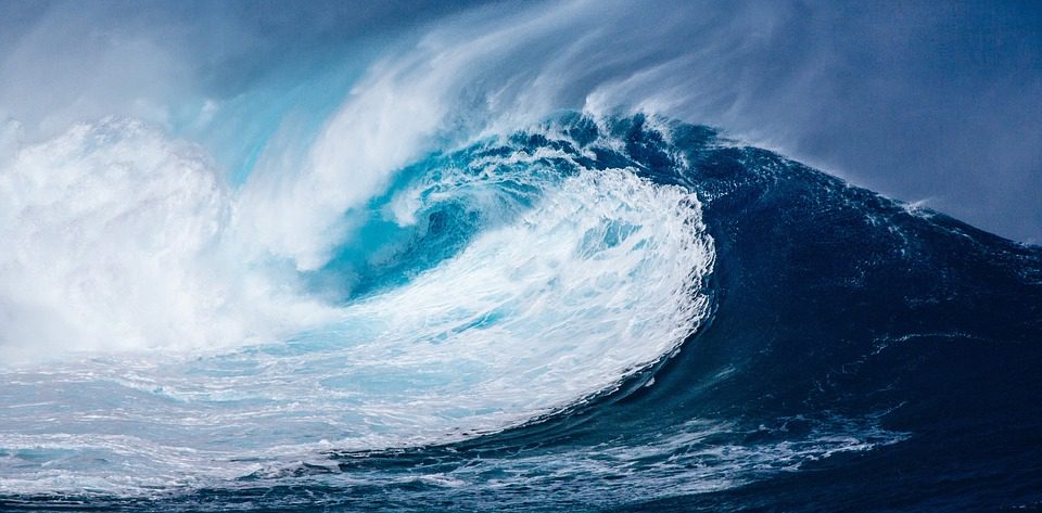
Forget what you think you know about tsunamis. Mega-tsunamis are in another class entirely. These waves, triggered not by typical earthquakes but by volcanic collapses or massive landslides, can initially rise over 2,000 feet high and travel at jetliner speeds—up to 500 mph.
Once dismissed as doomsday fiction, the risk is now backed by modern seismology, satellite data, and coastal geomorphology. And three U.S. regions—Alaska, Hawaii, and the Pacific Northwest—sit directly in the crosshairs.
Alaska: The Site of the Tallest Wave Ever Recorded
In 1958, Lituya Bay in Alaska was rocked by a seismic event that unleashed the tallest tsunami ever measured: 1,719 feet. A slab of rock the size of downtown San Francisco sheared off a cliff and exploded into the bay. The result? Water scoured mountaintops and stripped forests bare.
That wasn’t a fluke. According to NASA and the Alaska Division of Geological & Geophysical Surveys, warming temperatures are now melting the state’s glaciers faster than ever, destabilizing mountain slopes. A 2020 study warned that Barry Arm Glacier is on the brink of collapse, potentially sending another landslide-triggered tsunami roaring through Prince William Sound.
“Events of this scale are no longer hypotheticals—they’re statistical probabilities,” said Steve Masterman, Alaska’s geological chief.
Hawaii: Sleeping Volcanoes Could Unleash Oceanic Shockwaves
In the Hawaiian archipelago, the risk is buried deep beneath the surf. Around 105,000 years ago, a 1,000-foot-high wave struck Lanai, throwing marine fossils halfway up mountains. The trigger? A volcanic flank collapse—an entire section of a mountain falling into the sea.
Researchers highlight the Nu‘uanu Slide, a 20-mile-wide underwater debris field caused by a prehistoric landslide. It displaced billions of tons of earth, reshaping coastlines and generating waves hundreds of feet tall.
Fast forward to 2025: Kīlauea continues to show signs of instability, and Mauna Loa, the world’s largest volcano, is still active. The potential for another flank collapse is real. Penn State geophysicists confirm that seismic shifts could reawaken Hawaii’s capacity for mega-tsunamis.
West Coast: Cascadia Subduction Zone Ticking Toward Catastrophe
On January 26, 1700, a magnitude 9.0 megathrust earthquake ripped through the Cascadia Subduction Zone, just off the coast of Oregon and Washington. Within 15 minutes, a tsunami 100 feet high leveled Native villages from Vancouver Island to Northern California. The wave even crossed the Pacific, striking Japan.
Now, the USGS and FEMA say there’s a 37% chance of another M8.0+ event along Cascadia within the next 50 years.
If it hits during peak hours, coastal cities like Astoria, Newport, Tillamook, and parts of Seattle could be underwater in under an hour. Low-lying zones may drop 6–12 feet permanently, turning once-thriving towns into ghost lagoons.
Canary Islands: The Wild Card That Could Drown the Eastern Seaboard
While U.S. scientists monitor the Pacific, another danger looms in the Atlantic. The Cumbre Vieja volcano on La Palma is cracking. A 2001 study by Dr. Simon Day and Dr. Steven Ward modeled a worst-case collapse of its western flank—sending 120 cubic miles of rock crashing into the ocean.
The model shows a 2,000-foot wave near the island and a 150-foot tsunami reaching the U.S. East Coast in under 9 hours, inundating cities from Miami to Boston.
Is America Ready? Short Answer: No.
Despite decades of warnings, preparedness remains dangerously uneven. Many at-risk communities lack early-warning systems, evacuation infrastructure, or even updated inundation maps. The 2011 Tohoku tsunami killed 16,000 in Japan—one of the most prepared nations on Earth.
Now imagine a 10x larger wave crashing into cities with no warning, no barriers, and no public drills.
What You Can Do—Now
If you live in a tsunami hazard zone—especially in Alaska, Hawaii, Washington, Oregon, or California—here’s what you need to do today:
-
Know your elevation. If you’re below 100 feet near the coast, you’re at risk.
-
Study evacuation routes. FEMA and local agencies provide maps—use them.
-
Build a go-bag. Pack essentials for 72 hours: water, food, meds, ID, and radio.
-
Sign up for alerts. NOAA and USGS offer SMS/email emergency notifications.
-
Stay informed. Monitor volcanic and seismic activity from official sources.
Final Word: Don’t Wait for the Sirens
Mega-tsunamis aren’t just scenes from Netflix. They’ve happened—and will happen again. The U.S. coastline has already paid the price once. If you live near the ocean, this isn’t fearmongering—it’s physics.
The next wave won’t be just high. It’ll be historic.